MEECHING HALL
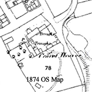
Section of 1874 OS Map
Old-maps.co.uk
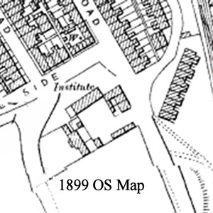
Section of 1899 OS map
Old-maps.co.uk
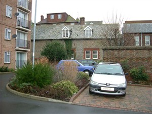
Side wall of Meeching Hall, Meeching Court Flats at left
OurNewhaven.co.uk
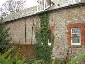
Side wall of Meeching Court
Ournewhaven.co.uk
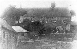
Meeching Court Farmhouse
Old Postcard RB Collection
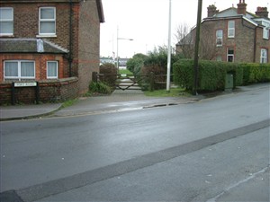
Entrance of old route to ford across river
Ournewhaven.co.uk
Fort Road
By Richard Beckett
Meeching Hall situated in Fort Road is the subject of a query on the Message Board and I feel that a photograph and sections of the official OS maps might be of help.
In very early descriptions of the area the buildings were known as "Court House", presumably a large house, and later as "Meeching Court Farm".
If you look at the OS map sections (photos 1 & 2), in 1874 the buildings originally in and around the area where "Meeching Court" flats are situated (note the name) were referred to as "Court House (farm?) ", and were a number of buildings around a courtyard, whereas on the 1899 OS map although all the original buidings still appear to be there set around the yard, only the present "Meeching Hall" is named and is shown as an "Institute". This could possibly have been used as a Masonic Hall for the Freemasons of Newhaven NOTE: I have since been informed that in fact the hall WAS in the ownership of a masonic lodge circa 1900. The map also seems to indicate that the remainder of the buildings around the open square appeared to have become part of "Meeching Court Farm" with the old Court / Manor house becoming the farm house
From the 1899 OS map it would appear that the building known today as "Meeching Hall" is one of the original buildings from "Meeching Court" which made up the farm. This may be why some people refer to it as the "Agricultural Hall".
Viewed from the outside, (photos 3 & 4) the walls of "Meeching Hall" appear to be constructed of the "Blue Boulders" collected from the west beach, some of which are Knapped, and has the appearance of a very old building which may substantiate the possibility that it was part of the original buildings of "Meeching Court" farm
Photo 5 is an old postcard with a view taken apparently from Fort Road and looking through the farmyard towards "Meeching Court Farmhouse".
Almost opposite the entrance to Meeching Court is a way through to the River Bank (photo 6) and it is on record that people have memories of cattle being taken at low tide across a ford at this point to graze in the fields on the eastern side of the river. (These memories must surely stem from the early 1800's before the railway wharves were constructed)