THE MOUNT PLEASANT BUILDING ESTATE c.1903.
The Mount Pleasant Building Estate. Be VERY glad it didn't happen.
By Geoffrey Ellis
A grand scheme for Mount Pleasant Building Estate was published in 1903 that provided for over 2430 20ft-wide by 100ft-deep plots with streets of shops and two hotels that would stretch from Wellington Road in Denton to Eversleigh Rise (parallel with Palmerston Road, but 300yds south east), and from Denton Corner to Mount Pleasant Road (Mount Pleasant Road would have run along the crest of the hill from Wellington Road to Eversleigh Rise). It proposed these other new roads: Station Road, Mount Road, King’s Avenue; Beresford Road, Arundel Road, Claremont Road, Seaview Road, Fairholm (sic) Road, Palmerston Road, Holmdale Road, Avondale Road, Alexandra Road, Albany Road, Talbot Road and Carden Road. (Although shown on the original plans, many of these roads failed to materialise).
Many plots were reserved for shops: 18 in Wellington Road; 46 in Denton Road; and 52 on both sides of Alexandra Road – 116 in total. Provision was made for two hotels: one at the bottom of Wellington Road, the other at the top of Denton Road. Fifty ‘apparently isolated’ parcels of land between the back gardens of adjacent roads had ‘block numbers’ but no planned means of access. Surprisingly no provision for community recreation or park space was allocated or proposed.
Initially in 1905, roads were laid out and water mains installed between King’s Avenue and Mount Road together with Beresford Road, Arundel Road, Claremont Road, and Seaview Road as shown on the Estate Plan that invited ‘Builders, Speculators, Investors and Others’ to attend an auction in London, with offers of free railway tickets and luncheon vouchers to anybody who might be ‘a probable purchaser’.
It was advertised as Mount Pleasant Estate at Newhaven-on-Sea, Sussex, adding, “The estate is situate only a few minutes from Newhaven Town Station (L.B. & S.C. Railway) (probably why ‘Station Road’ was so-named) at a splendid elevation rising to an altitude of 200 feet above Sea level, and commanding magnificent views extending over Newhaven Harbour and Pier to the Sea. It is within two miles of the rapidly improving watering place of Seaford, and within easy distance by rail of Brighton and Eastbourne.
“Water Mains are laid through the Estate, which is immediately ripe for the erection of Villa-Residences, Bungalows, Shops &c. Adjoining the Estate is the picturesque Village of Denton, with its Church, Post Office, and School. From the Harbour there is the Boat Service with Dieppe, the Boat Train from London Bridge and Victoria accomplishing the journey in little over an hour. There is also the interesting shipping constantly in and out of the Harbour. Land in this neighbourhood is rapidly increasing in value, the building operations at Seaford, and the splendid Marine Parade extending in this direction.
“From its important situation and nearness to the Railway Station, Harbour and Town of Newhaven, besides being within such a short journey by rail from London, this Estate should commend itself to Builders, Investors and Others as a sound and profitable investment. Taking into consideration the very easy terms of purchase, as set forth in the front page of these Particulars, and the reasonable price at which the Vendor is prepared to sell, the present opportunity should not be missed of acquiring building plots on the valuable Estate.”
Clearly considerable capital and effort had been invested into this venture. Had it happened, it would have dwarfed Newhaven; but for an unforeseen succession of reasons (the Great 1914-18 War, the post-war recession of the 1920s and the Great Depression of the 1930s) only a handful of properties ever materialised. Then came the Second World War.
With the declaration of war by England and France on Germany in September 1939, there became a need to prepare for the protection of the South Coast, particularly where there were pre-existing installations considered to be of military advantage – such as Newhaven Harbour with its port, marine workshops, and railhead. A military camp was required to accommodate soldiers defending the port and local hinterland with guns and searchlights, and also for troops in transit and there was nowhere better than the under-developed hillside estate to the east of the town and harbour to create it.
During 1940/41 a large military encampment was created on many undeveloped roads of the Mount Pleasant Estate, and more than 100 Nissen huts and military communal buildings occupied most of the vacant building sites. A separate page called ‘Mount Pleasant WWII Army Transit Camp’ has been created to describe this development in greater detail. It concludes with the post-war redevelopment of the 1950s and 1960s.
After the end of the war, most of the Nissen huts were taken over by the local authority and modified into temporary dwellings to accommodate those whose homes had been lost or damaged by enemy action pending redevelopment and reconstruction of the damaged properties. ‘Squatters’ occupied the two larger huts mentioned earlier on the corner of King’s Avenue/Arundel Road. Another page on this website called ‘More about Mount Road’ contains comments by former inhabitants of some of the Nissen huts.
Post-war development during the 1950s and 1960s saw the Nissen huts and army communal huts demolished, to be replaced with modern bungalows and houses, with buried main sewers and gas, water, electricity and telephone services, erected on plots of land originally determined by the Mount Pleasant Estate scheme of 1904. Most of the roads were fully developed with pavements, proper street lighting and main drainage and were adopted by the local authority, but a few still remain with the temporary road surface laid down by the army back in the 40s. These unadopted roads have since become seriously worn out through use and neglect and still await redevelopment at the time of writing.
Evidence of the grand scheme may still be found if you know where to look and what to look for in the shape of a surveyor’s reference point and some residual earthworks. A prominent marker stone with an embedded stud exists at the northernmost point of the proposed estate on the southern side of the track leading from Mount Pleasant to New Barn, where intersected by an imaginary line projected from the rear gardens of Wellington Road. See illustration for identification. Other visible evidence exists in the earthworks prepared for Alexandra Road and Carden Road when viewed from Palmerston Road. These last are most evident when viewed using Google Maps. (Search Google Maps for 'Palmerston Road, Newhaven').
On 12th November 2009 Hilary Benn, Secretary of State for Environment, Food and Rural Affairs signed an order confirming the designation of the South Downs National Park thereby 'ring-fencing' the current development, and sealing the fate of the Grand Scheme of 1903. See http://www.naturalengland.org.uk/Images/Map29_tcm6-14893.pdf for details.
Mount Pleasant Building Estate, Newhaven-on-Sea, 3rd Section, dated July 1903, showing Station Road, Mount Road, King's Avenue; Beresford Road, Arundel Road, Claremont Road, Seaview Road, Fairholm (sic) Road, Palmerston Road, Holmdale Road, Avondale Road, Alexandra Road, Albany Road, Talbot Road, Carden Road and Mount Pleasant Road.
Courtesy of Newhaven Local & Maritime Museum
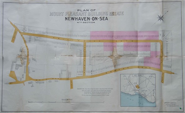
Mount Pleasant Building Estate, Newhaven-on-Sea, 4th Section, dated 2nd July 1903, showing Wellington Road, Denton Road, Thompson Road, and Talbot Road. A Wellington Road property owner told me, "A block of land was sold in September 1907 for £83 (thats a good price !) that consisted of 10 plots, each 20 feet by 100 feet deep on the top side of Wellington Road, Denton. The orignal owner of the land in 1903 was a Mr George Simmins". Before you consider that 'small change', remember that the purchasing power of money was more than one-hundred fold greater one hundred years ago.
Courtesy of Newhaven Local & Maritime Museum
Artists impression on the front cover of the proposed Mount Pleasant Freehold Building Estate, Newhaven-on-Sea, Sussex, Prospectus, c.1904
Courtesy of Newhaven Local & Maritime Museum
The back page of the Mount Pleasant Estate, Newhaven-on-Sea Prospectus, c.1904. With such emphasis on the advantages offered by the local railway at a time when railways offered the preferred means of travelling any distance, it is not difficult to appreciate the reason for naming a road that led towards the station as Station Road. It gave the false illusion of proximity to those unfamiliar with the district.
Courtesy of Newhaven Local & Maritime Museum
Invitation to an Auction in London, travelling and lunch expenses paid.
Courtesy of Newhaven Local & Maritime Museum
This photograph of Newhaven Harbour c.1906 unintentionally records the progress of the Mount Pleasant Estate road development at this time. Roads visible here include Carden Road, Alexandra Road, Palmerston Road, Eversleigh Rise, Holmdale Road and Avondale Road, many of which failed to be developed as proposed. Others include Station Road, Mount Road, Beresford Road, Arundel Road, Claremont Road, and Seaview Road that have survived and been fully developed.
Courtesy of Newhaven Local & Maritime Museum
Mount Pleasant Estate roads that never happened. Seen from Palmerston Road. Alexandra Road was planned to be a road full of shops - both sides! Search Google Maps for 'Palmerston Road, Newhaven' to get a 'bird's-eye view' of these 'green corridors'.
© 2010 Geoffrey Ellis
Another harbour scene fortuitously revealing the extent of the development, this time in the late 1930s. Development had been retarded for a variety of reasons (the Great 1914-18 War, the post-war recession of the 1920s and the Great Depression of the 1930s) . Over a thirty-year period only a handful of properties had materialised.
Courtesy of Newhaven Local & Maritime Museum
Surveyor's reference point. This granite block marks the northern corner of the proposed Mount Pleasant Building Estate of c.1904. It is located on the south side of the track leading from Mount Pleasant to New Barn, in line with the boundary of the edge of the field (to the right) and the back gardens of north side of Wellington Road. A stud in the top surface of the block marks the precise point. Dog-walkers who pass this point daily will no longer regard it as a curiosity. Almost certainly there would have been other markers, but none has been discovered to date.
© 2010 Geoffrey Ellis